SHASTA COUNTY – The Shasta County Air Quality Management District (AQMD) and the Public Health Branch of the Shasta County Health and Human Services Agency are advising all residents of Shasta County, to limit outdoor activities due to the presence of wildfire smoke. Wildfire smoke originating from the Carr Fire near Whiskeytown National Recreation Area, fires in Southern Oregon, and the Sierra Nevada are currently transporting increasing amounts of wildfire smoke into the populated areas of Shasta County. Certain areas may experience higher concentrations of smoke based on proximity to wildfires and current weather conditions. All members of the public, especially those with respiratory or heart disease, the elderly, pregnant women, and children should remain alert, and if necessary, reduce or avoid all outdoor exertion when wildfire smoke is present. Everyone else should limit prolonged exertion in areas of noticeable smoke accumulation. Individuals wishing to minimize their exposure should:
- Limit exercise and outdoor activities
- Remain indoors with the windows and doors closed
- Turn on an air conditioner with a recirculation setting (such as in a vehicle)
The Air Quality Management District operates one air quality monitor in Anderson that continuously monitors for fine particulate matter less than 2.5 microns in size (PM2.5). Some areas of Shasta County may experience higher concentrations of smoke than others depending on wind patterns and topography. All individuals are urged to use proper judgement when planning activities.
The AQI readings from the fixed monitors are updated hourly and are available at the following website: www.co.shasta.ca.us/index/drm_index/aq_index/aq_map.aspx
If the area you live in is not near a monitor, you can use this table to visually estimate the air quality:
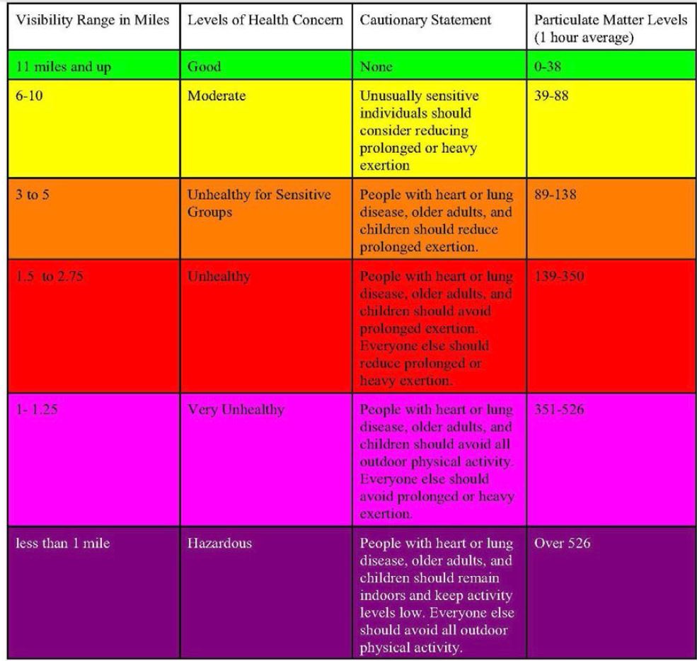
When using the visibility index to determine smoke concentrations, it is important to:
• Face away from the sun.
• Determine the limit of your visibility range by looking for targets at known distances (miles). The visible range is the point at which even high-contrast objects (e.g., a dark forested mountain viewed against the sky at noon) totally disappear.
• At times, the visibility index may be hard to use, especially if specific landmarks at known distances are not available for judging visibility range, or at dawn or dusk. Furthermore, the above visibility categories for PM levels only apply in dry air conditions. For a given PM level, visibility decreases substantially at relative humidity above 65%, therefore, this method of estimation should not be used under conditions of high humidity. At night or during periods when visibility cannot be used to estimate smoke levels, intense smoky odor can be used to indicate potentially harmful levels.
For additional information and updates, you may call the Air Quality Management District at
225-5674.
Additional safety tips can be found by going to www.shastahhsa.net and by clicking the “Protect yourself from wildfire smoke” link.